The Valley of the Sun
No other major city readily displays
exciting geology and great landscapes like Phoenix. Why?
GEOLOGY -- The
Valley of the Sun contains a wide variety of geologic features, including all of the major
rock types, formations dating from extremely old to very recent, and some very unusual
geologic structures. Phoenix and Scottsdale sit right in the middle of it all!
EXPOSURE -- The
arid environment has created excellent exposure of not only the rock formations
themselves, but also other physical features that make up the Valley.
VANTAGE POINTS -- A
number of high-elevation points in and around the Valley, and their easy accessibility,
allow for wonderful places from which to see these features. The lack of thick vegetation
at such locations means no peering through the bushes or trees in order to see the sights.
SCENERY -- Desert
weathering patterns and heat have created in this region a "look" that people
coming from the world’s populous temperate climates find exotic and fascinating
– the stuff of Hollywood movies relating the terrain of ancient Egypt, the Asian
silk-route caravans, or those cowboy westerns that the world loves!
WEATHER -- Clear
skies and good atmospheric conditions for hundreds of days a year make visibility great!
----------------------
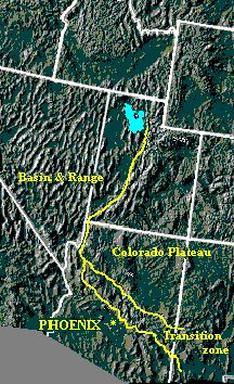
The grandeur of the Phoenix area is a product of its location near the
meeting place of two of the great geologic provinces of North America, indeed the world:
the Basin and Range, and the unique Colorado Plateau.
The Colorado Plateau, with its high, mostly flat-lying, colorful formations
that are seen so well in the Grand Canyon, lies to the north and east. Between it and the
metropolitan area is a relatively narrow transition zone of jumbled rocks and lava flows.
On the floor of the great valleys at the base of these regions lie Phoenix
and Scottsdale. Here and for hundreds of miles to the west, northwest, and south is the
Basin and Range – a great rip and tear in the fabric of the Earth’s crust -
where the rocks even now are being spread apart by immense forces of continental scale.
Blasted through by ancient volcanoes, sliced by fault systems, and rich in
mineral deposits, it is this province that gives our area its characteristic jagged
mountains and spacious valleys.
The digitized photograph below shows the approximate relationship of these
three regions.

The Desert Southwest of the United
States.
Source of photo: NASA
If this window appears as a full-size,
rather empty-looking web page, either you do not have scripting and "pop-ups"
enabled in your web browser, or you have found it only by way of a search function.
In the former case, you can return to the main website by using your
"Back" button, or by accessing our Home Page at www.gemland.com.
In the latter case, you will have to access our website's Home Page by going
to www.gemland.com.
If this window appears as a
"pop-up", simply close
this window to return to where you were.
[060811]
|